Let us know the features You are interested in > InvestInPiacenza at MIPIM > Area Ex Consorzio Terre Padaneback to searchback to map
Area Ex Consorzio Terre Padane
The area is historically anthropogenized and influenced by public and productive settlements now abandoned or little used, such as the Terrepadane Agricultural Consortium, the former fruit and vegetable market and other industrial buildings in the decommissioning phase.
Currently, the Agricultural Consortium is largely defunct, with only a few facilities still in use. The former fruit and vegetable market is largely unused, with the exception of some facilities used as a service for an experimental terminal. The analysis of the construction phases reveals a gradual development of the area, with the expansion and transformation of the Consortium over time.
The vast extension of the areas and the significant volumes require a unitary transformation project to balance public infrastructure, services and economic feasibility.
The recovery of the area could bring benefits to the entire city, eliminating disused industrial facilities in an area now used as residential/ commercial. This could lead to new green areas, public parking, the development of a network of services and promote significant economic growth.
Type of property
Area
Total size of the areas (covered/uncovered)(sqm)
128.077 mq
Total covered areas
45.000 mq
Owned by
Consorzio Agrario Terre Padane SCRL per 115.750 mq. City of Piacenza per 12.327 mq
Occupational Status
The building is unused
Maintenance Status
The property is to be renovated but it is in decent condition
Procedure required
Agreement between private parties
Address
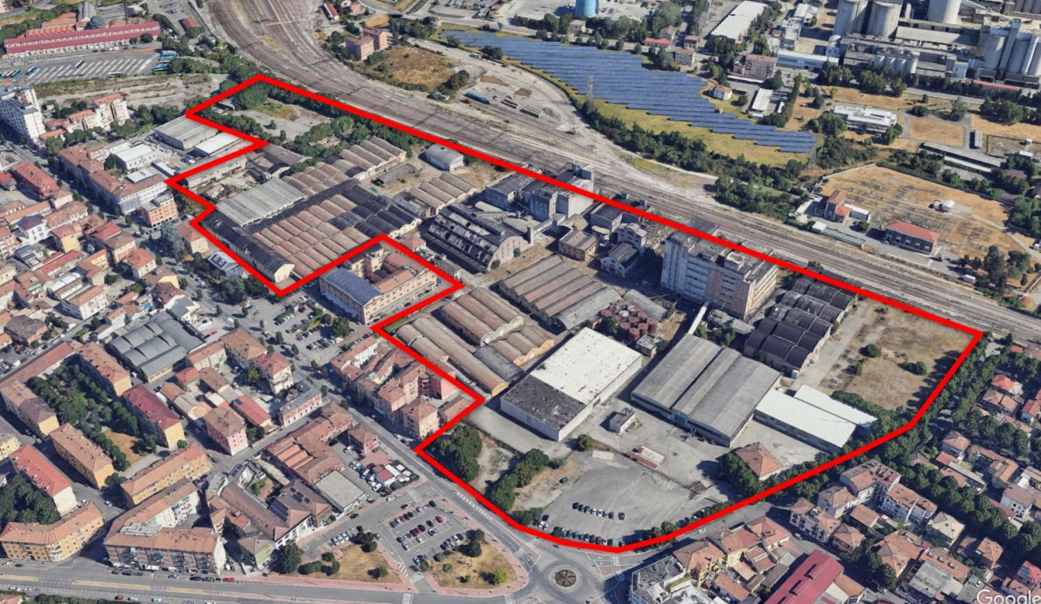
Via Cristoforo Colombo 31-33 part of the territory between the railway infrastructures that depart from the FFSS station in Piacenza towards Bologna and the urban section of the Strada Statale n. 9 Via Emilia
Municipality
Piacenza
Province
Emilia-Romagna, Province of Piacenza
Possibility of a territorial strategy
The area could have different uses. The area SLP destinable to trade and tertiary uses of support (restaurants, offices, service crafts, hotels, medical studios,...) is usable up to sqm 54.667,00 (Tertiary land available for the whole of the project, but which may be concentrated in individual lots according to the building plan). It could also have a special residential function: university and school students, sheltered old-age homes, off-site workers' housing, residences, cohousing and similar housing solutions. 9000 mq
Accessibility
The intervention area is located in the municipality of Piacenza, in the central-eastern part of the capital, in the portion of territory included between the railway infrastructures that depart from the Piacenza FFSS station directed towards Bologna and the urban section of the State Road n. 9 Via Emilia, an area therefore historically marked by intense anthropogenization. Specifically, the area analysed is affected and conditioned both by the presence of the mentioned infrastructures for mobility and by substantial public and productive settlements which, over time, have lost their function and are either abandoned or poorly used, that is to say the Terrepadane agricultural consortium and the former fruit and vegetable market, as well as some factories and warehouses, all in the process of being sold off and characterized by widespread states of degradation; the nearby complex of the Military loading plan (located at the western end in a contiguous area) has already been converted into an experimental public transport terminal. The settlement covered by the present analysis occupies a portion of territory with a surface area of 128,077 square meters and, as mentioned, is located in the central-eastern area of the capital of Piacenza. Specifically, the area occupies a large portion of territory bounded by the railway infrastructure of the line Piacenza-Bologna to the north, from SS 9 Via Emilia (Via Colombo) to the south, from Via Pennazzi to the east and from the settlement Borgo Faxhall to the east.
Distances
- 7 km from the nearest motorway
-1.3 km from the nearest passenger train station
-121 km from the nearest international airport
-149 km from nearest industrial/commercial port
-5.8 km from nearest rail freight terminal